As described in my previous hike's BLOG, I had been planning to hike and camp on this next hiking section. Unfortunately that plan did not come about mostly because I ran out of time to find a local B&B or establishment to allow me to park my car at the end point and/or drive me to my start point. I decided to drop the idea of a hike and camp weekend and found a B&B and did my usual two days of hiking.
It was a beautiful sunny and relatively cool Saturday and Sunday in late June, so perfect weather for hiking.
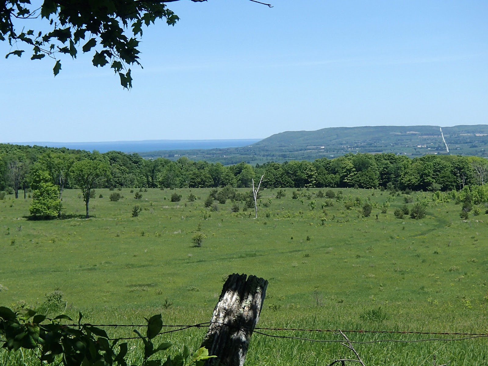
I had my B&B host help me drop my car in Walters Falls and then drive me back to my start point at the 107.5km mark of the Beaver Valley section. The trail headed south from Euphrasia St Vincent Townline through woods and continued south and then west through more woods and meadows along the upper edge of the escarpment.
Following are some photos of some nice flowers and plants along this section.
The trail met and crossed 7th Line and continued westward through woods and fields, again generally along the edge of the escarpment. At the 112.8km mark the trail passed Anthea's Waterfall, named after Anthea East, daughter of Dr. Tom East one of the founders of the Bruce Trail Club. Here are some photos from this section including some nice flowers and a memorial to a past BT member.


The trail came out on Grey Road 12 at the historic hamlet of Blantyre. Blantyre was settled in 1856 by James Patterson. By 1860 the busy village had 3 stores, a barrel make, various mills, a blacksmith, tinsmith, a hotel and school and two stagecoaches (one to Meaford and one to Owen Sound). James Patterson was the first postmaster and the Patterson family continued as the postmasters until the post office closed in 1924. With the arrival of the railway in 1870 the population of 150 declined quickly to today where it is almost a ghost town. On the west side of the road there is a very old, broken down shell of a building which I assume must have been a store or hotel of some type. The Beaver Valley section of the Bruce Trail ends at Blantyre and the Sydenham section begins.


The trail continued west from Grey Road 12 again through woods and fields along the top of the escarpment. At the 1.2km mark of the Sydenham section, there is a side trail leading down the escarpment a 100m or so to a camp site location, maintained by the local trail club. The 3 sided, open door shelter with bunks make for a nice shelter to set up in. This was the campsite I was originally going to shoot for to camp overnight. With the weather warming and increased humidity and with the campsite down below the escarpment, the bugs were thick and part of me was quite happy that I wasn't stopping and camping overnight - on the other hand, in the fall it would probably be a nice spot to stop and camp. Here are some photos of this section and the Ambrose campsite.


It was also along this section of the trail I got two adrenaline pumping situations. First, as I walked along the trail a ruffed grouse flew out of the bush beside the trail. This has happened a few times in the past but this time it was very close to the trail and startled me big time. In the past the bird would fly off and disappear into the woods. On this occasion though the grouse actually started to fly at me a number of times and then followed me on the ground for 15-20 feet making hissing noises - that was a new experience! I can only assume it had a nest close by and was in protection mode. Not long after this, in a fairly dense section of the woods on the escarpment, again all of a sudden, there was some loud huffing or grunting noises coming from ahead on the trail. It was clearly from something big. I had assume it was a bear and froze not sure whether I should continue. The noises continued so I backed up the trail a bit but in the end decided I couldn't go back and just started making some loud noises and started forward. I didn't hear anymore of the noises and didn't see anything but I can only assume it was a bear - not sure what else it could have been.
The trail came out on Deviation Road and re-entered a field on the west side of the road. The trail crossed Rocklyn Creek and then climbed steeply to woods continuing westerly to St Vincent Sydenham Townline at the 7.5km mark. The trail followed the Townline south up a steep hill back up onto the escarpment. The trail headed back into woods and fields along the top of the escarpment and then descended to the valley coming out on Grey Road 29 at the 10km mark.
The trail headed south crossing Grey Road 29 a couple of times and then followed Walters Creek up stream through the valley to Walters Falls.
Walters Falls was settled in 1850 by John Walter of Somerset, England. The settlement was originally known as Walters Place. He built a mill at falls and the first post office was built in 1855. The sawmill burned in 1984 but woolen and feed mill still stand today. In fact, the feed mill continues to be a thriving business in town still operating using water power.
I picked up my car and headed back to the B&B, Chrysalis Ranch B&B, just outside Walters Falls. Chrysalis is a horse ranch and working farm and the accommodations and service were great. That night I went into Meaford and had dinner at the Leaky Canoe - food and the Corona were great!
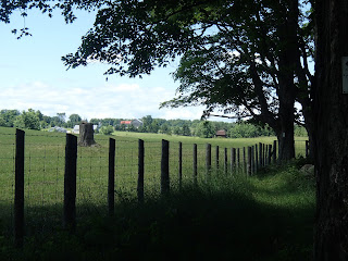
Next morning my B&B host helped me drop my car at my end point and then drove me back to Walters falls to the start of my day's hike. The trail picked up crossing Walters Creek above the falls and headed back north along the west side of the valley. The trail continued to head north past Grey Road 29, past Holland Sydenham Townline, following along beside and above Walters Creek. At the 13.9km mark the trail turned and headed west along a fence line to 2nd Concession. Here are some photos from this section.
The trail followed 2nd Concession south for 600m and then turned west and followed Holland Sydenham Townline for 2.7km. Here are some shots from this area including photos of a very picturesque Holland Sydenham Cemetery.
At the 17.8km mark the trail turned north and followed 4th Concession crossing the Bighead River near the 18.9km mark. The Bighead River originates inland near Chatsworth and flows through the Bighead River valley and empties into Georgian Bay at Meaford. The Bighead River is a prime river for steelhead trout fishing in spring and fall.
From here the trail turned west through a meadow and past a private property and house and then steeply climbed the escarpment to the 20km mark. It continued west for about 1km and then turned north through woods and fields to the 22.1km mark at Sideroad 3 where I parked my car. Here are photos from this section.
Another wonderful two days of hiking!
Completed: 581.0km
All of my recent hikes, as I head further north on the Bruce Trail, have involved a weekend, hiking both Saturday and Sunday or some cases, hiking over two week days.
I had finished my previous hike at the 85.8km mark of the Beaver Valley section. I had also been looking forward to potentially hiking the early parts of the Sydenham section and camping at the two BT campsites along the trail. When I hike and camp, I carry my large pack with all my camping gear and food, etc and history tells me that I shouldn't try to hike more than about 10km a day. With the Ambrose campsite at the 1.6km mark and the Big Head campsite at the 20km mark of the Sydenham section, the 10 km daily hike limit fit nicely assuming I started my hikes at the 107.5km mark of the Beaver Valley section. The idea would be to start at the 107.5km mark, hike to the Ambrose campsite and camp, hike to Walter's Falls (and stay in a B&B), hike to the Big Head campsite and camp and then finish up at the parking lot at the 29.7km mark of the Sydenham section.
With all of the above in mind, hiking from the 85.8km mark through to the 107.5km mark of the Beaver Valley section totals only 21.7km or 10-11km per day on a two day hike. 10-11km is just not enough for one day. On the other hand, 21.7km in one day would be a pretty "epic" hike for me. Only one other hike (Spencer's Gorge single day hike) was this long - about 23km.
In the end I chose to do the 21.7km in one day - a beautiful, windy and fairly cool Saturday in early June.
I arranged through my previous B&B host, Barb Danby of Danby House B&B in Markdale, to help me get to and park my car at the end of the days hike and then drop me back to the beginning of the hike.
I started my hike about 10am at the parking lot at the 85.8km mark with no idea of just how "adventurous" today's hike would end up being!
The trail generally followed the top edge of the escarpment for 2km at which point the trail turned west along Sideroad 16C for 300m. The trail turned and headed north through farmers fields with some nice views out over the Beaver Valley. The trail continued east and north through fields and woods until it met Sideroad 19 at the 91.2km mark. Here are some photos from this section.
A Shasta daisy (as I would call it but not sure if this one is a more native version that is called something else). The second photo is a whole field of these daisies!
Here is a photo looking across to Metcalfe Rock and Mill Creek valley on the east side of the Beaver Valley, where I hiked earlier this spring.
Also looking across the valley to Old Baldy!
The trail followed the sideroad for 300m and turned north through fields to a short side trail to a large beaver pond.
A Buttercup (as I would call them).
The trail continued through dense cedar woods and then turned east along edges of farm fields until it met Highway 7 north of the village of Epping.
The village of Epping sits high on a hill overlooking the Beaver Valley. It was established by Scottish settlers in mid 1800's and the post office was the first in Grey County. The mail route covered Epping to Meaford but later was extended to Flesherton, a 2 day journey by horse. The population of Epping never exceeded 50 people and by early 1900's started to decline. All that remains today is a boarded up Mount Hope Methodist Church.
On the east side of Highway 7, I took a side trail to the John Muir Lookout (also known as the Epping Lookout). There was a nice park with shelter and tables and a nice view out over the Beaver valley.
John Muir was born in Scotland and emigrated to Wisconsin in 1849. He was intensely interested in botany and geology. He set out to explore and hike parts of Canada including Ontario and the present day Bruce Trail. His brother worked in a rake factory near Meaford - he convinced John to work at the rake factory and settle in the area. In 1866 John Muir returned to the US spending many, many years as a leading champion of conservation including establishing the Sierra Club. He petitioned the US congress in 1890 to preserve western US forests leading to a National Parks government bill and the establishment of many US National Parks, so much so that today he is known as the "Father of National Parks".
From there the trail followed Highway 7 north for about 2km and then turned east and followed Sideroad 22B to the edge of the escarpment and valley - here it became an unmaintained road that wound down the escarpment heading east into the valley for 2km.
At the 96.2km mark I decided to take the Siegerman Side Trail, mostly because the description in the guide sounded like this side trail was a nice hike. The side trail initially passed an old stone foundation from a house and then through woods to a point where it turned east and descended into a deep ravine following a very beautiful stream until it met 3rd Line C. At 3rd Line C, the original foot bridge was washed out years ago so a very old split log snowmobile bridge allows for crossing to the north side of the stream.
For the next 1.5km the trail followed the unmaintained 3rd Line C, steeply climbing up out of the ravine and back up onto the escarpment.
A mother and baby chipmunk on the road.
At the intersection of 3rd Line C and Sideroad 25 my "real adventure" for the day started. My 2012, Edition 28 maps told me that the trailed continued north on 3rd Line C turning onto Old Mill Road and meeting Highway 40 at the 101.1km mark, so that's how I continued my hike.


I did find it strange that along this section there were no white blazes but didn't think much of it at the time. The maps told me to turn west and travel along Highway 40 for a few hundred meters and then turn north into a field. I hiked along Highway 40 and did not see a trail heading to the north - no blazes, signs or styles. I hiked further along Highway 40 for another 500 meters but still didn't see anything. At this point it became clear that there must have been a trail re-route at some point in time and that the current trail was somewhere else. I was pretty tired and didn't want to retrace my hike back to find where I had obviously missed a turn for the re route. So, I decided that I would risk going back to where I believed the old trail headed north off Highway 40 on my old map and use my "orienteering and bushwhacking" skills to follow the old trail until some point where I hoped it would meet up with the re routed, current trail. It was tough slogging through the fields and along fence lines although I guessed I was on the right path as every once in while I would see an older path down under the overgrowth. Finally after about 2km of "guessing" I was on the right trail, low and behold I met the re-routed, current trail around the 103km mark. RELIEF!
The bushwhacking took a lot out of me and I was getting pretty tired and sore at this point but pushed on for the remaining 4km to my car. The trail climbed the escarpment and followed it past many crevices (and through one crevice) until it met Highway 7 again.
The trail picked up on the west side of Highway 7 and continued along the escarpment. The final kilometer or so was through woods until the trail finally came out on Euphrasia-St Vincent Townline at the 107.5km mark.
I was very glad to see the car!
Lesson learned!! Before hiking, check the "Re-Routes" section on the Bruce Trail website to see if there are route changes on the your hike. Had I done this before hiking I would have seen that the trail was re-routed a couple of years ago, going west at the 99.1km mark and then heading north through to and crossing Highway 40 about 300 meters west of where I got to on Highway 40 looking for the trail. Taking into consideration my extra hiking, looking for the old trail, I probably walked another 1km more than my planned 21.7km.
I certainly didn`t appreciate it at the time I was bushwhacking across the fields but in the end this challenge definitely added some adventure to my day`s hike.
Completed: 552.6km