I had my B&B host help me drop my car at my first day's end point and then drop me at my start point at the Woodford Community Center at the 42km mark of the Sydenham section.
The trail headed northeast into the woods along the escarpment, passing the foundation of a pioneer church and an old limestone kiln, fashioned from a glacial sink-hole.


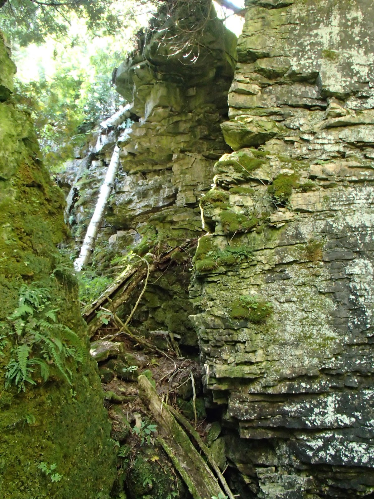
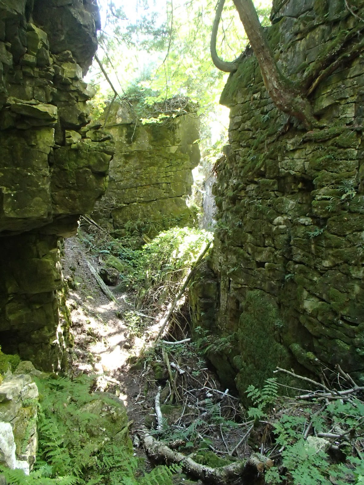
The trail continued eastward descending and ascending the escarpment. At about the 43km mark the trail entered a very narrow and deep crevice. A bit of a technical climb down and up out of the crevice but very neat!


At the 44.4km mark the trail met St Vincent Sydenham Townline and turned north. My Edition 27 maps showed the trail turning east at the 45km mark and through a farmers field but there was no right turn marker to be found. I did have the BT app on my phone so I checked that since I was in the open, and sure enough this 2km section was closed and the trail re-routed north along the Townline and then back down the River Kwai Sidetrail back to the main trail. Unfortunately the re-route was unexpected and added about 5-6 km to my days planned hike. Here are some photos from this section.


I got back to the main trail at the 46.9km mark and headed north along the escarpment. The trail passed mostly along the top of the escarpment affording some nice views to the east and northeast looking out over the Meaford Land Forces Training Center or generally known as the Meaford Tank Range.
In 1942 the Canadian Department of Defence expropriated about 800 square kilometers of land on Cape Rich between Owen Sound and Meaford to support tank and artillery training. It affected families of some 150 farms. By 1943 when it officially opened as Camp Meaford, there were 30 1 tonne tanks on site and some 10,000 people trained. Today it is known as the Land Force Central Area Training Centre and is one of the largest year round training facilitates in Canada. Looking out off the escarpment on the range lands, it's a bit spooky looking as the land is pretty barren of trees and landmarks - it does look like an area that has had heavy use. My B&B host mentioned that even today she hears explosions and sees large flashes as military training takes place. Here are some photos of this section.


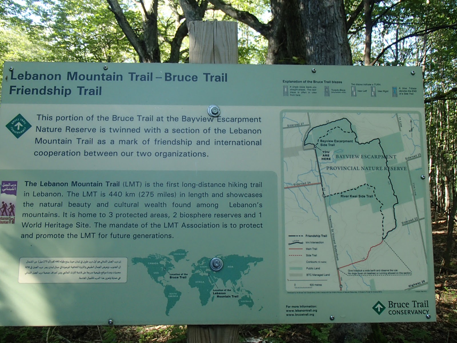
This section of the trail was also interesting in that it passed through the Bayview Escarpment Provincial Nature Reserve and part of the trail is named or twinned with the Lebanon Mountain Trail in Lebanon. As the trail continued north towards the 50.8km mark there were many very deep crevices at the escarpment edge.
The trail continued north and then east along the escarpment edge finally coming out at the Townline again just a few kilometers north of my parked car (which you can see in the distance in the photo below).


I finished up at the car and drove into Owen Sound for dinner at Norma Jeans Bistro - dinner was very nice! Owen Sound is a city of 21,000 people today. There area was surveyed in 1815 by William Owen who named it after his brother Admiral Edward Owen. The settlement was originally known as Sydenham but in 1851 renamed to Owen Sound. Due to the busy shipping port, it became known as "Corkscrew City" or "Chicago of the North" due to it's very rowdy nature. A tavern known as the "Bucket of Blood" was 1 of 4 bars located at the corners of "Damnation Corner" - 1 block away was an intersection known as "Salvation Corners" with churches on each corner! Due to it's historical rowdy nature, public drinking houses were banned and the city was dry until 1972. The city is home to Billy Bishop one of Canada's greatest pilots who fought in WW1, even battling Germany's Red Baron. Another important citizen is Tom Thomson, one of the original Group of Seven painters.
I headed back to my B&B east of Owen Sound between Bognor and Walters Falls. The B&B is Solstice B&B and was a wonderful place to stay. It is a late 1800's church beautifully restored. The owner, Blue, is a stained glass artist - lots of hers and other local artists work was on display. The accommodations and breakfast was wonderful - highly recommended for anyone looking for a place to stay although the owner is trying to sell. Thanks for the hospitality Blue and good luck wherever you end up. Here is a photo of the church and view west at dusk.

The next morning my B&B host helped me drop my car at my end point for the day and drop me back to my start point. I picked up the trail at the 56km mark. The next 6km or so of the trail followed Sideroad 24, 2nd Concession N and Sideroad 22. Here are some nice photos from along this section.


At the 62.5km mark the trail turned south along a field hedgerow, into woods and then finally came out on Irish Block Road at the 64.7km mark. The trail continued southwest through woods again until it came out at a spot over-looking Highway 26 between Owen Sound and Meaford. I stopped at this point and had lunch sitting on a rock in the shade. Here are some photos from this section.


The trail then headed west along Highway 26 for 1.6km. A fairly wide shoulder on the highway but definitely a bit disconcerting walking along such a busy highway.

Looking back east on my highway walk.

At the 66.6km mark the trail headed north off Highway 26 into the woods beside a farm and through very interesting escarpment rock formations.


At the 67.5km mark a Sidetrail veers off to the Lloyd Laycock Cave. An up and down trail through narrow crevices in the escarpment led to a large cave back into the escarpment. Here are some photos of this Sidetrail and the cave.


Another wonderful 2 days of hiking - looking forward to the next hike!
Completed: 627.8km
No comments:
Post a Comment