I had finished my previous hike at the 85.8km mark of the Beaver Valley section. I had also been looking forward to potentially hiking the early parts of the Sydenham section and camping at the two BT campsites along the trail. When I hike and camp, I carry my large pack with all my camping gear and food, etc and history tells me that I shouldn't try to hike more than about 10km a day. With the Ambrose campsite at the 1.6km mark and the Big Head campsite at the 20km mark of the Sydenham section, the 10 km daily hike limit fit nicely assuming I started my hikes at the 107.5km mark of the Beaver Valley section. The idea would be to start at the 107.5km mark, hike to the Ambrose campsite and camp, hike to Walter's Falls (and stay in a B&B), hike to the Big Head campsite and camp and then finish up at the parking lot at the 29.7km mark of the Sydenham section.
With all of the above in mind, hiking from the 85.8km mark through to the 107.5km mark of the Beaver Valley section totals only 21.7km or 10-11km per day on a two day hike. 10-11km is just not enough for one day. On the other hand, 21.7km in one day would be a pretty "epic" hike for me. Only one other hike (Spencer's Gorge single day hike) was this long - about 23km.
In the end I chose to do the 21.7km in one day - a beautiful, windy and fairly cool Saturday in early June.
I arranged through my previous B&B host, Barb Danby of Danby House B&B in Markdale, to help me get to and park my car at the end of the days hike and then drop me back to the beginning of the hike.
I started my hike about 10am at the parking lot at the 85.8km mark with no idea of just how "adventurous" today's hike would end up being!
The trail generally followed the top edge of the escarpment for 2km at which point the trail turned west along Sideroad 16C for 300m. The trail turned and headed north through farmers fields with some nice views out over the Beaver Valley. The trail continued east and north through fields and woods until it met Sideroad 19 at the 91.2km mark. Here are some photos from this section.


A Shasta daisy (as I would call it but not sure if this one is a more native version that is called something else). The second photo is a whole field of these daisies!


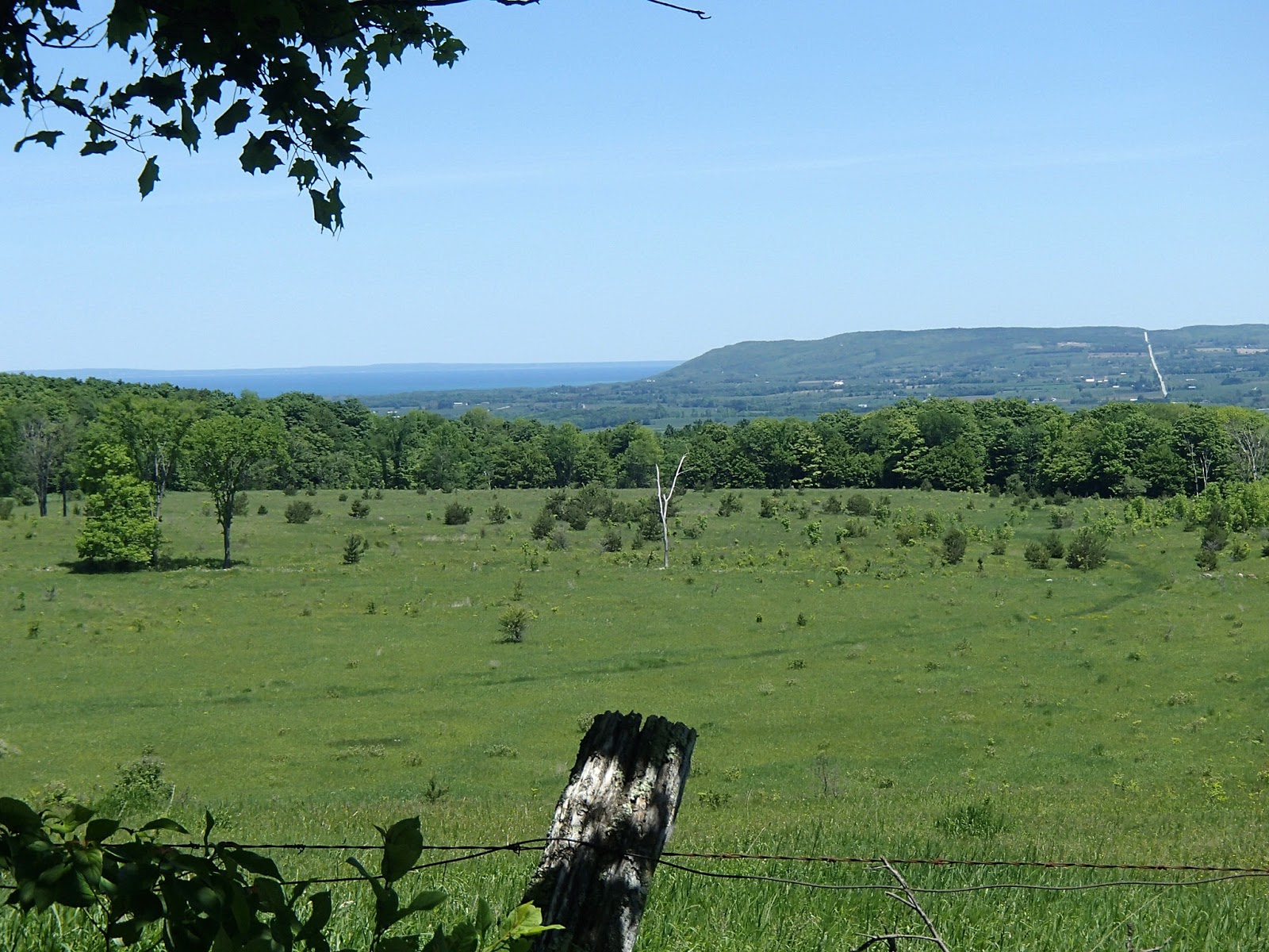
Here is a photo looking across to Metcalfe Rock and Mill Creek valley on the east side of the Beaver Valley, where I hiked earlier this spring.

Also looking across the valley to Old Baldy!


The trail followed the sideroad for 300m and turned north through fields to a short side trail to a large beaver pond.

A Buttercup (as I would call them).

The trail continued through dense cedar woods and then turned east along edges of farm fields until it met Highway 7 north of the village of Epping.

On the east side of Highway 7, I took a side trail to the John Muir Lookout (also known as the Epping Lookout). There was a nice park with shelter and tables and a nice view out over the Beaver valley.


John Muir was born in Scotland and emigrated to Wisconsin in 1849. He was intensely interested in botany and geology. He set out to explore and hike parts of Canada including Ontario and the present day Bruce Trail. His brother worked in a rake factory near Meaford - he convinced John to work at the rake factory and settle in the area. In 1866 John Muir returned to the US spending many, many years as a leading champion of conservation including establishing the Sierra Club. He petitioned the US congress in 1890 to preserve western US forests leading to a National Parks government bill and the establishment of many US National Parks, so much so that today he is known as the "Father of National Parks".
From there the trail followed Highway 7 north for about 2km and then turned east and followed Sideroad 22B to the edge of the escarpment and valley - here it became an unmaintained road that wound down the escarpment heading east into the valley for 2km.


At the 96.2km mark I decided to take the Siegerman Side Trail, mostly because the description in the guide sounded like this side trail was a nice hike. The side trail initially passed an old stone foundation from a house and then through woods to a point where it turned east and descended into a deep ravine following a very beautiful stream until it met 3rd Line C. At 3rd Line C, the original foot bridge was washed out years ago so a very old split log snowmobile bridge allows for crossing to the north side of the stream.


For the next 1.5km the trail followed the unmaintained 3rd Line C, steeply climbing up out of the ravine and back up onto the escarpment.


A mother and baby chipmunk on the road.

At the intersection of 3rd Line C and Sideroad 25 my "real adventure" for the day started. My 2012, Edition 28 maps told me that the trailed continued north on 3rd Line C turning onto Old Mill Road and meeting Highway 40 at the 101.1km mark, so that's how I continued my hike.


I did find it strange that along this section there were no white blazes but didn't think much of it at the time. The maps told me to turn west and travel along Highway 40 for a few hundred meters and then turn north into a field. I hiked along Highway 40 and did not see a trail heading to the north - no blazes, signs or styles. I hiked further along Highway 40 for another 500 meters but still didn't see anything. At this point it became clear that there must have been a trail re-route at some point in time and that the current trail was somewhere else. I was pretty tired and didn't want to retrace my hike back to find where I had obviously missed a turn for the re route. So, I decided that I would risk going back to where I believed the old trail headed north off Highway 40 on my old map and use my "orienteering and bushwhacking" skills to follow the old trail until some point where I hoped it would meet up with the re routed, current trail. It was tough slogging through the fields and along fence lines although I guessed I was on the right path as every once in while I would see an older path down under the overgrowth. Finally after about 2km of "guessing" I was on the right trail, low and behold I met the re-routed, current trail around the 103km mark. RELIEF!
The bushwhacking took a lot out of me and I was getting pretty tired and sore at this point but pushed on for the remaining 4km to my car. The trail climbed the escarpment and followed it past many crevices (and through one crevice) until it met Highway 7 again.


The trail picked up on the west side of Highway 7 and continued along the escarpment. The final kilometer or so was through woods until the trail finally came out on Euphrasia-St Vincent Townline at the 107.5km mark.
I was very glad to see the car!
Lesson learned!! Before hiking, check the "Re-Routes" section on the Bruce Trail website to see if there are route changes on the your hike. Had I done this before hiking I would have seen that the trail was re-routed a couple of years ago, going west at the 99.1km mark and then heading north through to and crossing Highway 40 about 300 meters west of where I got to on Highway 40 looking for the trail. Taking into consideration my extra hiking, looking for the old trail, I probably walked another 1km more than my planned 21.7km.
I certainly didn`t appreciate it at the time I was bushwhacking across the fields but in the end this challenge definitely added some adventure to my day`s hike.
Completed: 552.6km
No comments:
Post a Comment