April 25/26 was my first weekend Bruce Trail hike of 2015. It was sunny and clear but cool in the 6C to 10C range.
I drove to the B&B I was staying at and the hosts drove me out to park my car at the end of the day's hike and then on to the start of my hike at about the 11km mark of the Beaver Valley section of the trail. I started along 18th Sideroad and then the trail descended down through some woods and across some nice meadows to at point where it descended steeply into the Indian Brook valley. Here are some pictures from this part of the hike.
The trail followed Indian Brook and then crossed at a bridge. Beside the bridge was a large, fairly deep pond of water. To my surprise, there were two large (approx. 18" in length) fish in the pond - not sure what they were, maybe tout or salmon. I guess they had swam upstream from the Beaver River in the Beaver Valley, to spawn. Here are some pictures.
Still some signs of winter hanging on!
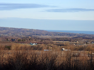
Some pictures looking out towards Georgian Bay as the trail followed along Highway 119.
The trail headed south from the road through meadows and some woods with more beautiful photos looking west towards the Beaver Valley and as the trail followed and crossed a creek around the 18km mark.
The trail turned west along 12th Sideroad for 700m and then turned south again into meadows and woods.
Trilliums that will bloom shortly!
Around the 19.2km mark the trail followed, for a short distance, the Old Mill Road. Old Mill Road was a pioneer road used between 1830 and 1850.
The trail continued south crossing the 9th Sideroad through some beautiful woods with nice views again looking out towards Georgian Bay and the Beaver Valley.
I finished up at the 23.8km mark where the trail met Highway 2. From there I hiked about 600m south along the road to the Kolapore parking lot where I had parked my car.
I headed back to my B&B for the night - Ravenna Hill B&B. Gisela and Jürgen's house was beautiful, located just north of the village of Ravenna, perched high up on the edge of the Beaver Valley. A wonderful place to stay. Here are some pictures from the B&B.
The next morning I dropped my car at my end point and got a drive back to my starting point for the day at the 23.8km mark. The trail headed west through some nice cedar and deciduous woods - here are some pictures from this part of the trail.
At the 27km mark I arrived at the edge of the escarpment not realizing how much I had slowly climbed, as the escarpment was quite high at this point. Just past this point, the trail passed Metcalfe Rock. Metcalfe Rock is a very large slab of the escarpment that broke away from the main escarpment creating a 30 meter deep crevice. There is a side trail down into the crevice and out but it looked quite technical - I didn't take it as rocks were still a bit to slippery. Here are some pictures from this section.
Once down off the escarpment, the trail headed west through woods to the Mill Creek valley. The trail descended and ascended through the valley and continued west where it steeply descended and ascended another valley before arriving at Pinnacle Rock. Pinnacle Rock is another very large piece of the escarpment that broke away and stands alone - very imposing! Here are some pictures from this section.
Interesting trail marker to direct you along the trail and not onto private property!
The trail continued north along the escarpment with beautiful views back across to Metcalfe Rock and looking out over Georgian Bay.
The trail came out on 9th Sideroad and followed it turning north on the Blue Mountain Eugenia Townline. Lastly, the trail followed Fox Ridge Road west for almost 3km. Wrapping up a cool and windy day, this last 3km of road walking was probably the toughest part of the day's hike - tired and cold!
I arrived at my car at the 37.6km mark and headed home happy to have successfully started my 2015 hiking season.
Completed: 481.8km


No comments:
Post a Comment