My younger son and I travelled north west of Owen Sound for a day hike, picking up at the finish point from our early December 2015 hike. My older brother, who lives in the area, met us and followed us to our end point for the day and then gave us a lift back to the start point around the 131km mark of the Sydenham section.
The trail headed north along Lundy Lane and then east along Concession 20 for 1km.
Here are some photos around the hike start.
The trail turned north and followed Cole's Sideroad for another kilometer where it continued as an old logging road that headed north up the escarpment. The old road was in rough shape - deeply rutted and lots of standing water and was fairly steep at the top of the escarpment. Here are some photos from this section.
The trail continued north along the old logging road through the woods for another 2km and then turned east off the road at the 136.3km mark. For another 2km the trail headed east and south through beautiful hardwood forests.
Here is a photo of a rotting log covered in a fungus of some type - interesting though it was the only log in the area with the fungus?
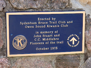
At the 138.3km mark there was a cairn paying tribute to CC Middlebro and John Stuart who were two early pioneers of the Bruce Trail, helping to build the trails in this section in the 1960's. Here is a photo of the cairn.
The trail entered the Kemble Mountain Management Area. Kemble Mountain is a large headland of escarpment that rises several hundred feet above the surrounding countryside. It is a leftover from the glacial age and was shaped by Georgian Bay when it's level was much higher. The area is considered an ANSI (Area of Natural and Scientific Interest) as it is home to 2 provincially rare and 8 locally rare plant species.
Additionally, the Nils Maher Sidetrail headed east off the main trail at this point. Nils was a local naturalist and Bruce Trail supporter. He was an authority on ferns and helped to educate the public on the 20 odd types of ferns in this area.
The trail turned to the east and met and crossed Kemble Rock Road at the 139.7km mark. Very scenic views at this point looking south off the mountain towards the village of Kemble. Here is a photo of this area.
The trail continued east passing another plaque in honour of Robert Samuel Edmonstone who made this land available to the local Conservation Authority for preservation of both the area and the trail.
The trail followed the upper edge of the escarpment turning and heading north - again beautiful views out over the escarpment towards Owen Sound and Georgian Bay.
The trail descended the escarpment around the 141km mark. The trail became a bit more challenging as it climbed over and around the talus rocks and through some nice crevice areas.
At the 142km mark the trail climbed back up to the top of the escarpment through a break in the rock and then continued north along the top of the escarpment.
At about the 143km mark the trail turned west along the edge of the escarpment and at times climbed down and followed along through crevices in the rock formations, many of which still had a good amount of snow in them!
The trail finally came out on Kemble Rock Road at the 144.1km mark where we had parked the car.
The first hike of 2016 was great - first of many this season, hopefully culminating with touching the northern BT cairn in Tobermory late summer or fall this year!
Completed: 703.1km


